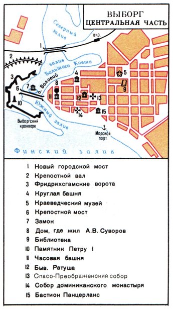
General information
Vyborg is one of the biggest and the most beautiful towns of Leningrad
region. It is situated in the North-Western part of the Isthmus of Karelia,
on the shore of the Gulf of Finland, 130 km North-West of Saint-Petersburg.
The main part of the town occupies a peninsula which is cut by deep bays,
the rest is on several small islands. The landscape is very rough,
the highest point of the town (at 33m above the sea level) is on
Batareynaya Gora (Battery Hill).
Vyborg attracts many tourists by its scenic surroundings, remarkable
architectural monuments, including, among others, remaining old
fortifications closely related to many centuries of the town's history.
Vyborg is an important transport hub, connected by the railroad network
to Saint-Petersburg, Moscow, Karelia, and Finland. The town lies on the
international highway E-18 which runs from Helsinki to Saint-Petersburg.
Vyborg has a commercial sea port and a shipyard. Proximity to richer Finland
creates in this poor provincial town a certain atmosphere: names of many shops,
bars, banks and restaurants are bilingual - in Finnish and Russian.
After Baltic states with their beautiful medieval towns have separated from Soviet Union,
Vyborg became a unique place in Russia. It is now the only fully European town on
the Russian territory. Sure, the outskirts of Vyborg consist of samples of socialist
times architecture, but the center! The castle on the island, the tower of the City Hall,
Kruglaya (Round) and Chasovaya
(Clock) towers, Anna's fortifications, stone-paved roads, medieval buildings of the Old Town,
magnificent landscape park Montrepos with a 19th century estate -
all this invites a comparison of Vyborg to an open-air museum.
In the surroundings of Vyborg there are many conifer forests, cut by numerous
rivers and lakes. In the district many Soviet and Finnish military fortifications
dating from the last war survived.
History
 |
| Vyborg Castle |
The history of Vyborg starts in 11th century, when a small settlement appeared at
the place occupied now by Park Montrepos. The inhabitants were hunters, fishermen, and
peasants; they also traded with the countries at the Baltic coast. Karels,
who were the majority of the population, for a long time had good relations with Novgorod
Slavs, who, in their turn, were trading with German and Swedish towns via the Gulf of
Finland and the Baltic Sea.
Sweden tried to conquer these lands already in the middle of 12th century, and in 1293
the ruler of Sweden, Torkel Knutson, lead a huge army into Karelia. To keep important
strategic positions, Swedes built in the same year 1293 a stone castle on a small island
Linnan-Saari (Castle Island). Novgorod tried to take the lands several times, and
even succeeded in 1318, however, only for a short period. In 1323
Russian-Swedish peace treaty was signed in the fortress
Oreshek. The treaty set Russian-Swedish border
along River Sestra. Novgorod ceded to Sweden a part of the Isthmus of Karelia
which included Vyborg, some lands beyond River Vuoksa, and lands around Lake Saima.
The Eastern part of the Isthmus of Karelia remained in the possession of Novgorod.
In the following years, the Swedish owners of Vyborg and their Southern neighbours
from Novgorod continued to live side by side peacefully like brothers. In 1351, and
again in 1411, the Southern brothers strongly damaged the town, and in 1475 the Northern
brothers for whatever reason started to build a wall around the town, and were,
according to some historians, in a big hurry.
Meanwhile, some changes have happened at the Russian territory. In particular,
the title of the biggest, strongest, and the most peaceful city was awarded to Moscow,
which, in these respects, has become a successor of Novgorod.
In the end of 15th century it was ruled by Ivan the Third, who became famous,
as well as the majority of the following princes and some of the princes preceding
him, for gathering Russian lands. At the time, nobody really knew what lands have
to be gathered, and what lands are truly "native"
Russian, and they were collecting everything from the Arctic Sea and the Urals down
to Chernigov
and the Baltic sea. In particular, it was decided to conquer Vyborg. In 1495
a big detachment of liberators arrived to the town and almost encircled it. For
ten weeks starting from October the army of Ivan the Third kept the siege, however
without success. Swedes also were getting in troubles: once a wall broke down under the
fire of Russian cannons, once naval ships sent to help the town were stopped by
stormy weather, once supplies were almost over. Nevertheless, after an especially
unsuccessful attack, the Ivan's army left Vyborg, leaving it for the time
being (more than 200 years) in the Swedish possession.
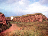
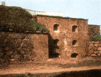
 |
Fortifications on
Batareynaya Gora
(Battery Hill).
19th century |
In 1703 Peter the Great founded the new capital of the Russian Empire - Saint-Petersburg -
on the islands in the mouth of River Neva. To ensure its safety, Peter now had
to conquer the Isthmus of Karelia and Vyborg - the main Swedish fortress
at the Northern shore of the Baltic sea and the Gulf of Finland. In 1706
he attempted to attack Vyborg from the land, but Swedish fortifications
remained undamaged. Only after the success in Poltava battle, in the Spring of 1710,
Peter performed a march to Vyborg. 13 thousands of Russian troops and artillery under
the command of admiral-general Apraksin crossed the Gulf of Finland on the ice from the
island Kotlin and started the siege of the town. In April Peter brought through the
icy gulf to Vyborg the navy of 250 sail and row ships to help the land troops.
On June 12, 1710, the Swedish garrison of Vyborg surrendered - justice triumphed.
Praising the importance of conquering the fortress of Vyborg, Peter said that
"the capturing of this town finally provided the safety for Saint-Petersburg".
The Nystad peace treaty with Sweden recognized Russian access to the Baltic Sea.
Between 1710 and 1811 Vyborg and surrounding lands were part of Russia. During
this time Vyborg became a sea port used for trading with Western countries
(Great Britain and Holland).
The last Russian-Swedish war in 1808-1809 decided the fate of Finland, which
turned from a province of Sweden into the Special Great Principality with
its own constitution and parliament and became a part of Russia. In 1811
Vyborg Governorship was administratively incorporated into the Great Principality
of Finland. These events caused certain changes in political and economical life of
Vyborg and the whole governorship. After the Saimensky Canal was built in 1856,
a huge influx of cargo went to the terminals of the Vyborg sea port. In 1870
a railroad was constructed which connected Vyborg with Helsingfors and Saint-Petersburg,
and later with other cities. Trade became even more intense,
factories and plants grew, new banks appeared. In 1912 the population of
Vyborg reached 32000.
 |
Anna's fortifications.
18th century |
Vyborg was naturally affected by the revolutionary events of 1917 as it happened to
be very close to the "Cradle of the Revolution", Petrograd. The leader of the revolution,
Vladimir Lenin, visited Vyborg on several occasions in 1906-1907 and in 1917. Starting from
September, 17
he was staying in the working suburb Talikkala (currently Village named after Lenin) at
15, Aleksandrovskaya ulitsa (street), now
Rubezhnaya ulitsa. Here, in 15,
Rubezhnaya
ulitsa, in 1958 a memorial museum was opened.
On December 18, 1917, in Smol'ny Palace Lenin handed to the head of Finnish delegation
a decree of Soviet of People's Commissars which recognized Finland as an independent state.
In March 1918 they even withdrew Russian troops from Finland. Subsequent operations
intended to overthrow Finnish government and support of anti-government gangs failed
to open a new victorious page in the history of new Soviet state - Finland remained
independent.
For the sake of the truth, we must note that Finland, which at the time included Vyborg,
did not appreciate the friendship with the Eastern neighbour - Soviet Union.
Together with other aggressive militarists - Great Britain, Belgium, and France -
Finns dug all over the Isthmus of Karelia, creating the line of so-called
defence. Later it became known as "The Mannerheim Line". The construction
took twelve years which were spent to create more than two thousands of
gunfire points and other fortifications. The construction spanned over 135 kilometers
along the front line (between the Gulf of Finland and Lake Ladoga), and as far as
95 kilometers away from the front into the Finnish territory.
The line consisted of several strips: first, the security strip which included
fortified positions, fences, and obstacles; the main defence strip with
22 resistance areas followed. There were also the second defence strip,
the rear strip, and Vyborg fortifications proper. It is not clear from whom
the Finns were going to "defend" themselves at the Soviet border.
Meanwhile, in the end of 1939, USSR proposed new peace initiatives.
Their essense was that Finland must peacefully cede to Soviet Union a large piece
of its territory close to Petersburg. On November 30, 1939, about a million of Soviet
soldiers, supported by about 2000 tanks and 1000 military planes started to convince
Finns to solve the problem peacefully. There were three directions of convincing:
one - in the Isthmus of Karelia, another one - North-East of Lake Ladoga, and the third one -
at the coast of the Arctic Sea. Despite the fact that the Finnish army
had 60 tanks, 115 military planes, and little more than 300 thousands troops, on March
13 the war ended. The border was moved, and Vyborg was included into Soviet Union.
In 1941 the Finns decided to use the opportunity and turn the history back.
They managed to occupy quickly the lands which belonged to them before the
war and reach the abolished border along River Sestra. Vyborg was taken by
the repatriating enemy on August 21, 1941. As a result of advance of the
Leningrad Front at the Isthmus of Karelia, on June 20, 1944, the town was taken again,
this time by Soviet troops. Finland was forced to quit the war, and on September 19,
1944, as a result of the cease-fire, Vyborg and the Isthmus of Karelia rejoined
Russia (then Soviet Union). Vyborg was designated to be one of 15 cities
which had to be restored with the first priority. By 1948 all industrial
enterprises were restored, new factories were under construction, multi-storey
residential and office buildings were being constructed. The role of Vyborg as
a railway and a sea port terminal, and as a cultural and tourist center, increased.
Attractions
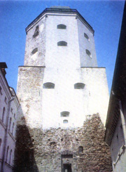 |
This tower is
48.6 meters high |
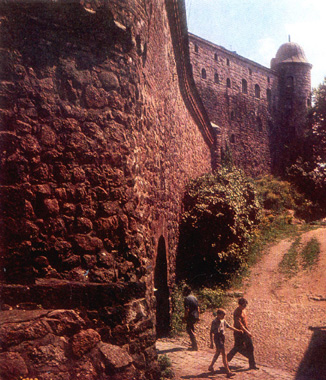
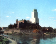
Attractions and architectural monuments of Vyborg are closely connected with its
history. Thus, from the period when the town was under Swedish administration, we have,
first of all, the Vyborg Castle, built in 1293.
The castle stands in the middle of a straight on a small rocky island about 1700
meters long and 122 meters wide. Over the centuries the castle was
reconstructed several times and acquired additional buildings.
Thus, between 1561 and 1564 the Olaf's tower was rebuilt.
The walls became thicker, the height was reduced, and one got a mighty seven-storey
tower. In 1856 as a result of fireworks celebrating the opening of the Saimensky Canal,
the castle was seriously damaged by fire, and after the restoration in 1891-1898 it
assumed the current form. The tower with the dome is 48.6 meters tall, the maximal
width of the walls is 5 meters, and there is a panoramic point on the top of the tower,
where one enjoys a wonderful view of Vyborg. Currently the castle hosts a museum.
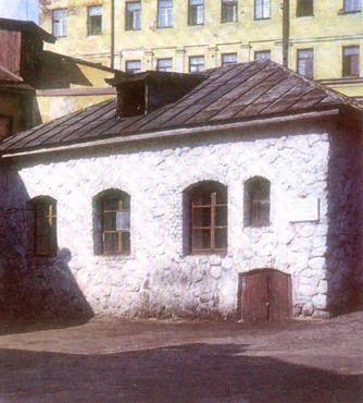
In the end of 15th century the settlement, with the exception of the Castle on the Island,
was surrounded by a fortress wall with towers, of which
Bashnya Ratushi
(City Hall Tower - Vyborgskaya ulitsa) survived
till our days. In 1490 Chasovaya
Bashnya (Clock Tower) was built - the bell-tower of the local Cathedral
(Krepostnaya ulitsa, 5 - in the inner yard).
It has got a name of Clock Tower in 1753, when the clock was mounted. For a long
time the Clock Tower served as a fire observation point, and after the fire of
1793 Catherine the Great gave the town a bell with a royal inscription. The bell
is still on the Clock Tower, producing a music already for over two centuries.
Close to the Ulitsa Vodnoi Zastavy there is one more
architectural monument of 16th century - Hyacinth
Catholic Church. Between Vyborgskaya and
Storozhevaya streets one can see a building from
14th century - House of the Merchant Guild.
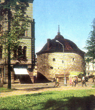
Of the fortress wall, built by the Swedes in 1550, one tower survived - the mighty
Kruglaya Bashnya
(Round Tower), which is now in the center of Rynochnaya Ploshchad'
(Market Square), next to the building of the market, built in 1905. In 1564
construction of Rogataya Krepost' (Fortress with Horns),
as it was known then, started. Its only preserved part is
Pancerlaks bastion
(Shell of the Gulf in Swedish), which is on the corner of Vyborgskaya
ulitsa and Leningradsky prospect. The medieval house on
13, Krepostnaya ulitsa (entrance from
ulitsa
Krasina), is from 16th century; it is built of big stones and resembles the tower
of the fortress wall. Close to it there are interesting old buildings along
Progonnaya ulitsa (means Drive Street), which ends at
the gulf and keeps its name from the times when herds were driven here to pastures.
 |
Pancerlaks bastion.
16th century |
Just next to the gulf on Progonnaya ulitsa stands a two-storey
white house with a balcony. On a rounded corner, there is a memorial board. In 1829
in this house, then the hotel owned by Motti, stayed a famous composer,
Mikhail Glinka, with friends, among whom was Anna Kern - four years before Pushkin
wrote to her one of his most famous poems. Memories of breathtaking beauty of Northern
landscapes, of a road between rocks, lakes, and woods, of songs of a Finnish coachman
inspired the composer to write "The Finnish Song" and the ballad of Finn in the
opera "Ruslan and Ludmila".
Prior to the beginning of 17th century Vyborg did not have a general development plan.
After big fires of 1638 the first general plan was produced - the town was divided into
rectangular quarters. The fortress square, which started right behind the bridge,
in the Middle Ages was an administrative and a trade center. In the middle of the square
there is a remarkable four-storey building, which was constructed in 1643 for the
town hall. At the time, it had only two floors, and
got another two later - in 19th century. At the same square there is a low-height
building of the town gate guard
from 18th century.
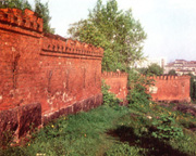
Vyborg preserved one of the few examples of a bastion fortress of 18th century survived
to our days - Annenkron (St. Anna's Crown).
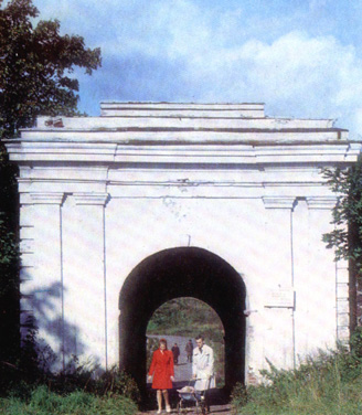
Anna's fortifications were started under Peter the Great, and finished in 1740s during
the reign of his niece empress Anna Ioannovna. The contest for the best project of
fortifications received applications from many respectable fortification engineers of the time,
including General Gannibal (known as "The Arab of Peter the Great", since he was brought
as a child from Ethiopia), and was won by General de Coulomb. This fortification
line contained four gates, but only Friedrichshan gate
is well-preserved. It is still used for communication between the two parts of the town.
 |
Ulitsa Yuzhnogo Vala
(South Rampart Street) |
A part of the old town, sharply carved into the gulf as a cape, is enclosed by two
beautiful streets - ulitsa Severnogo Vala
and ulitsa Yuzhnogo Vala (North and South Rampart Streets).
Not far from them, in the old town, two churches are built: Russian Orthodox Cathedral
of Transfiguration of Our Saviour (architects L'vov and Brockmann, 1787) and
Evangelic (Lutheran) Saint Peter and Saint Paul Cathedral (architects Brockmann and
Foelten, 1799). At the corner of Krepostnaya ulitsa and
Sovetskaya ulitsa there is a building constructed in 1895 for
Vyborg Governorship Administration, currently hosting Vyborg Municipal Council. Opposite
to it stands a splendid two-storey building constructed in 1891 (project of
architect Arenberg) to host the Vyborg governor residence; now it is
the Administration of the town and the district.
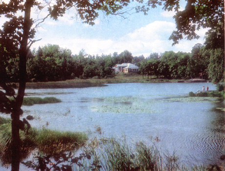
One of the numerous Vyborg attractions is
Park Montrepos
at a picturesque island 2 km from the town. This is one of the biggest estate ensembles
from 18-19th centuries preserved in the North of Leningrad region.
Of interesting buildings from the beginning of 20th century, one can mention
Construction Bank (1910,
prospekt Lenina, 2), building of the
post office (1912-1914, the corner of
Krepostnaya ulitsa and
Sovetskaya ulitsa), and the building of former
girls lyceum (1916,
Shkol'naya Ploshchad').
Of important buildings dating from 1930s we should mention the building of the
Archive (1933, architect Ullberg),
and definitely the building of the Central Municipal
Library, designed by the prominent Finnish architect Alvar Aalto in 1935.
It is situated in a beautiful park, running along prospekt
Lenina. The park was founded in 1862 at the place of demolished ramparts and
bastions of Rogataya krepost'. Alleys of the park
are a good place for walking tours, there are two remarkable brass sculptures
"A forest boy" (1932) and "A moose" (1924).
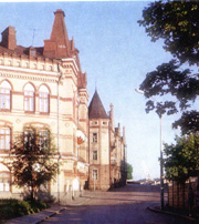
 |
Vyborg branch of
Construction Bank.
1910 |
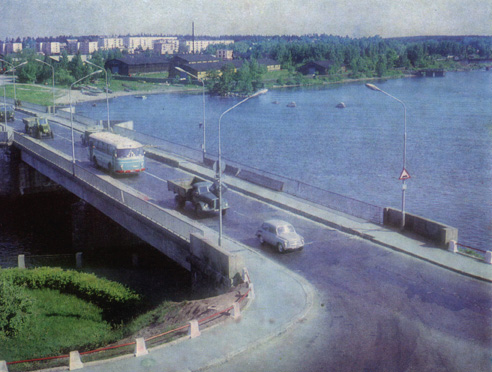
The central avenue of the town is prospekt Lenina,
which up to Krasnaya Ploshchad' (Red square) passes
through the area with houses mostly from 1860s - this is a very picturesque part
of the town. Currently, the avenue is built all the way to Batareynaya
gora (Battery Hill), which provides a panoramic view of the town. At this
place, in 1863-1864 East-Vyborg fortifications were constructed. The longest avenue
of the town - Leningradskoe shosse (Leningrad Road) -
passes Batareynaya gora. This road is a part of the
international highway E-18 Helsinki - Saint-Petersburg - Moscow. More recently,
the town received the buildings of the railway station, the bus terminal, and the sea
passenger port, new bridges, and many other modern residential and municipal buildings.
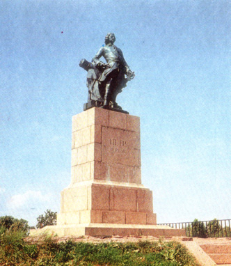
In 1910, when 200 years from the day Vyborg was returned to Russia were celebrated,
on the historical St. Peter's Hill a monument to Peter the Great was opened. Sculptor Bernstam
portrayed Peter leaning on a cannon, the tsar's figure is majestic, he is looking at
the fortress. Wild granite rocks at the gulf coast, water up to the horizon,
centuries-old lime-trees and silver-leafed poplars - a beautiful view of the
town opens from this place to the eyes of an amazed traveller...
|