General Information
 |
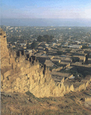
| View of Naryn-Kala citadel and a part of the town wall from the East |
Dagestan, a beautiful mountainous country, is glorified by numerous poets, writers and
artists. Its unforgettable landscapes, original way of life, remarkable carpets,
jewellery, pottery and other crafts produced by masters who speak dozens of different
languages always surprised and delighted everyone even remotely acquainted
with the country.
Beyond any doubts, every traveller is also impressed by the town of Derbent,
the oldest in Dagestan, and actually in the whole Russia. It is much older
than our country itself, older than the "eternal city" Rome, and it already
existed when modern states could not be even imagined on a geographic map.
Derbent is 5000 years old.
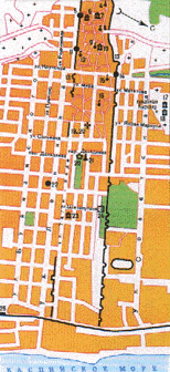
"The town is situated at the West coast of Caspian Sea, where Caucasus mountains
approach the shore very closely, leaving only a narrow strip of a seaside plain
about three kilometers wide. In the ancient times, here lied the famous Caspian way -
the only convenient road from the steppes of South-Eastern Europe to the
Middle East. The first settlement on the site of modern Derbent appeared on this road,
in one of its most strategically important and geographically convenient places".
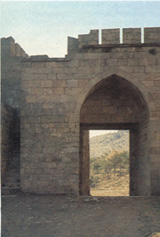
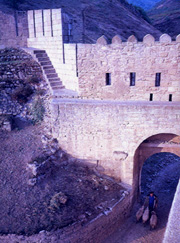 |
| Gate of Dzharchi-Kapy. View from the inner side |
This is the place where rich and prospering agricultural peoples of Middle East
"fenced" themself off from devastating raids of nomadic tribes from the steppes
of South-Eastern Europe.
The idea to intersect a large strip of land between the sea and the high mountains by a wall
sounds like science fiction; however, we can see the wall with our own eyes.
The idea to make two such walls with the town as a passage between them is not less
original, and this is what was done. Finally, the Mountain Wall which heads from the fortress to the West,
far into Caucasus, even though can not be regarded as an exceptional invention, has
an importance quite comparable to that of the Great Wall of China. We must add though
that it is shorter and unfortunately worse preserved.
In different times numerous peoples gave various names to the town (more than twenty
in total), but all of them are related to the word "gate". The name "Derbent" is
Persian, originates from 6th century AD and literally means "Knot of gates" or
"Lock of gates". Russians called this place Derben' or Zheleznye Vrata (Iron Gate).
Detailed descriptions of this remarkable town were compiled by many admiring
observers of various epochs, including Alexander Bestuzhev-Marlinsky, an author and a decembrist
(a participant of the December 1825 officer uprising against Tsar Nicholas 1st) who was sent here to exile. According to him, the town was like
"an enormous boa sprawling down the mountains with all its scales of houses bathing in the sunlight, with the Naryn fortress raised up as a toothed head, and with its tail playing in Caspian sea".
The firm laying of ramparts and towers, which endured more than one assault
during milennia, is well preserved (with few exceptions) till our
days. This provides for a modern traveller a unique opportunity of mental communication
with contemporaries of long disappeared tribes and peoples.
History
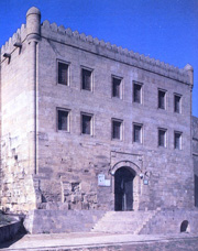
 |
| Building of the guard-room in the citadel (1828) |
On the basis of reliable sources and examinations of remains of Derbent ancient
fortifications survived till our days, one concluded that the town was founded in
6th century AD by Persian Sassanid rulers, and the "founding father" was thought to be
Khosrau I Anushirvan, who first protected himself in this site by the walls
from Khazar raids from the North. Thus, the conclusion was that the age of Derbent
is quite respectable, almost 1500 years.
However relatively recently, in 1971, archaeological excavations started which
eventually produced truly sensational results, making obvious that the site witnessed
much more ancient times.
Excavations revealed an ancient settlement, which was founded approximately in the end of 4th - beginning
of 3rd milennium BC - that is, five thousand years ago! On the premises of the now
existing citadel they found remains of construction, numerous artifacts, agricultural
implements, and granaries, which give evidence for the existence here of one of the most
ancient agricultural economies, typical for contemporaneous civilizations of the Middle East and South-Eastern
Europe. Ancient fortifications with traces of fires and destruction, and Scythian bronze
arrow tips found in the excavations confirm that when Scyths in 8th - 7th centuries BC
were on their Middle East campaign, they already had to assault well fortified Derbent.
Excavations uncovered a mighty fortress with walls of the rough stone, which was
erected at the turn of 8th century BC and with some renovations and rebuildings existed
till the Sassanid rulers came. Thus, Naryn-kala citadel was built in the 6th century AD
on the remains of much more ancient layings.
 |
| Building of khan's office above the gate of the citadel (reconstruction). Gate of Naryn-Kala-Kapy |
In 3rd to 1st century BC on the lands of modern Azerbaijan and South Dagestan a new
state was created - Caucasus Albania - which at the time included Derbent. 1st - 3rd
centuries AD became the time of flourishing of Derbent, as made obvious by a large
amount of goods and decorations imported from Syria, India, and Egypt, found in the
burial grounds from this time. Specially treated carved stone, clay solution, and
alabaster started to be used in construction. Appearance of square fortress towers
demonstrates further advances in the art of fortification.
In the middle of 3rd century AD Derbent was seized by Persian king Shapur II,
who "produced destruction and fires". But the town finally fell to the
Persians only in 4th century AD, and a new important stage of construction of powerful
fortifications started under Khosrau I Anushirvan (531-579).
"Construction of Derbent complex was divided into several stages: first, the citadel and
the North wall of the town, then the South wall, and then the Mountain wall
(Dag-Bary). Also, in 6th century the first transverse wall was constructed, which
separated living areas of Derbent and unpopulated seaside parts (two other transverse
walls appeared in 10th - 18th centuries)". Intensified construction of Derbent
fortifications took place in the situation of permanent instability, due to appearance in
4th century BC Hun state, and then Khazar Kaganate.
In 6th-7th centuries Derbent becomes a developed medieval town, characterized not only
by its military importance but also by a high level of social and economic
development.
Arab tribes united by Islam created a powerful state - Arab Caliphate, which finally
destroyed the Sassanid Empire. Arabs immediately started the fight to capture Derbent,
and in the beginning of 8th century won it over from Khazars. Famous Arab military
commander Maslama ibn Abd-al-Malik, a close relative of caliphs, is called by
historians "the second father" of Derbent thanks to his fruitful town-planning
activity.
"Under his guidance, Derbent becomes a prominent military and political center of
Caucasus, and also a permanent residence of a very large garrison and of Caliph's deputy-governor.
Here they got taxes and provision from the entire North-East Caucasus area. From here
Islam was spreading out".
In the struggle with Shirvanshahs, Emirs of Derbent were helped by Rus tribes, who
were their allies at the time. Paramilitary units, consisting of Slavs and Norsemen,
sailed down River Volga to the Caspian Sea and attacked West and South coasts,
but never plundered allied Derbent, which put at their diposal a convenient harbour
and a base for replenishing provision and repair of their ships.
However, mighty ramparts of Derbent did not save Russia from Genghis Khan.
In 1222, "Tartars crossed Caucausus via unassailable places, filling abysses
up with wood, stones, throwing down there their baggage, even horses and military
amunition". And in 1223, River Kalka battle started a somber epoch of Tartar
occupation of Russia. In the following decades, the Mongols ravaged surroundings of
Derbent, and the economy came to a decay. In the second half of 14th century,
the occupation by the troops of Tamerlane added up, and in 16th century Derbent
got at the center of violent battles between Turkey and Safavid state (which lied in modern Azerbaijan, Iran, and Iraq).
Safavid Shah Abbas inflicted an important defeat on Turkey in 17th century, and
started to restore Derbent port and fortifications.
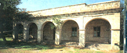
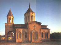 |
| Armenian church (19th century) |
From 18th century, Eastern Caucasus and Derbent entered the sphere of state interests
of Russia. On August 23, 1722, Peter the Great with his troops entered Derbent without a
battle. He wrote then to the Senate: "Naib of this town brought (us) keys from the
gate. It is true that these people accepted us heartily, not hypocritically, and
are so glad as if we have rescued our own people from the siege". Peter highly valued
the importance of Derbent. He ordered to repair walls, gates, and other
fortifications. In memory of his visit, the town inhabitants conserve a dug-out where the great emperor allegedly stayed.
But Derbent was finally annexed to Russia only in 1806. In 1820, with an active
participation of General Ermolov (who was in charge of annexing Caucasus) the
building of the lower, seaside part of the town began. A part of the South wall
was demolished, and new residential areas on a rectangular grid of wide streets
extended beyond the wall. In contrast to the European-like pattern of the seaside part,
the western part of the town, close to the citadel, preserved spectacular oriental
ligature of old magals with narrow streets running between the walls, which hide green cosy inner yards.
The coat of arms of Derbent was approved March 21, 1843. Its description is
interesting: "... On the right, interlaced roots of mudder plant and several
poppy stems, tied up by a golden rope, to symbolize that the inhabitants successfully
process mudder and cultivate poppy to obtain opium."
An important role in the development of the town played the construction of the
railroad from Russia to Baku via Derbent, opened in 1900. It was a symbol of the
new age. Like if a giant stone bar, for thousands of years closing the road along the
Caspian Sea, finally was lifted.
Attractions
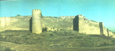 |
| Naryn-Kala Citadel. Viwe from the South |
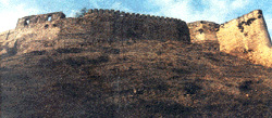
Undoubtedly, the most interesting, truly unique and not reminiscent of any existing
system of urban fortifications is the fortress complex of Derbent itself. The main part of
the system of fortifications - Naryn-Kala citadel
(one of possible translations of this name is "Solar Fortress"), built on a high
spur of Dzhalgan mountain range in 6th century. Powerful three-meter thick walls,
enclosing the area of 4.5 hectares, are built of two rows of well-treated stone
blocks, filled in between with untreated stone and mortar. The same construction
is used for the town parallel walls, the
North one more ancient and the South one more recent. Both walls have many
towers. Long time ago, these walls continued far
into the sea, thus making the roundabout way impossible and creating a convenient and well-protected harbour.
An interesting monument, vividly demonstrating an old age of the town, is found
in the North-West part of Naryn-Kala citadel. This underground structure, built
in the shape of a cross, and covered by crossed arches, for a long time
was considered to be a water reservoir cut out in the rock. However, an attentive
archaeological study showed that it is a cross-vaulting Christian church.
It was built on the ground in 5th century, and then sank into mighty cultural layers.
Historians say that Derbent till the middle of 6th century was a centrum of
Christendom in Caucasus.
 |
| Gates of Kala-Kapy. View from the inner side |
North and South town walls have several gates, of which the most interesting
and the most architecturally advanced one is Orta-Kaly (Middle Gate).
In course of many centuries, walls, towers, and gates have undergone multiple repairs. Architectural
details of the upper parts of the walls and the towers, as well as of apertures of
the gates, represent various periods of development of architecture and art of construction.
An important place among the town attractions belongs to structures for water conservation and consumption.
Water was of an almost exclusive importance for any town-fortress. It
originated from springs on the slope of Dzhalgan mountain, and went by stone and
ceramic water-pipes, many of which were discovered during the excavations, to
several underground water reservoirs, including the old Christian church adapted for this
purpose. Also, several ancient fountains, which
are still used by inhabitants as sources of drinking water, are preserved in Derbent.
They include Khai-Bulakh (Khan Spring), Dgiarchi-Bulakh (Messenger Spring), and others.
 |
| A part of the town wall and town magals |
Also are of interest ancient baths preserved
in the town. One of them is in the central, elevated part of the citadel. This is an
underground structure from 17th century with dome arches, several rooms for cold and
hot compartments and for undressing, and with reservoirs for cold and hot water.
The citadel has a beautiful view of the town below. Among flat roofs, cut by
narrow streets, raise domes of numerous mosques. They remind of the times of Arab
domination. The biggest, oldest and prettiest of the mosques is
Dzhuma (8th century).
One also sees well from the citadel large ancient cemeteries
of Derbent, with many stone monuments and sarcophagi from 5th - 9th centuries, marking funeral sites of many
courageous defenders of the fortress, fallen in different ages.
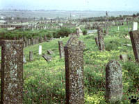 |
Cemetery.
Photo: V. Dinets |
In the south-western corner of the fortress wall there is a rectangular aperture,
leading to the corner tower. This tower formerly served as an entrance to
Mountain Wall (Dag-Bary),
which started from here. Only small parts of this wall survived, but their
examination showed that this wall was a huge construction 3 meters wide and 10
meters high, with many forts, semi-forts, and rectangular towers. This
powerful defence line, twisting on the mountainous landscape, went into Caucausus
for more than 40 kilometers.
It goes without saying that the town with 5000 years long history collected so many
attractions that they can fill more than one thick book. Such books are written and
splendidly illustrated.
|